The Soil Carbon and Water Resilience Project
Project Background
The Soil Carbon and Water Resilience Project, funded by the Environment Agency, brought together the soil carbon data collected by Carbon Quester in the North-East Cotswold Farm Cluster and combined it with Atkins Realis’ Natural Flood Management (NFM) Studio tool under the supervision of Carbon Quester’s partners at Rothamsted Research. The aim of the project was to take an empirical soil carbon dataset and combine it with the latest hydrology modelling, to further understand, measure and quantify the link between soil carbon and natural flood management. This project was designed to help farmers, businesses, and policymakers better understand the critical role of soil carbon and landscape-scale management in water resilience and landscape recovery.
Aims & Approach
The project has the following core aims:
- To integrate soil carbon data with hydrology modelling to improve our understanding of how, and by how much, improvements in soil carbon percentage can impact water retention and natural flood management.
- Use empirical datasets to improve resolution and understanding on soil carbon and water storages capacities
- Consider the uplift potentials of soil carbon and water storages following land use change scenarios
- Link with biodiversity data to understand contribution of different plants to carbon capture and flood management.
How Increasing Soil Carbon Improves Natural Flood Management

This project explored how increasing soil carbon can improve water retention and help manage floods. We combined data from the North-East Cotswold Farm Cluster with advanced hydrology modeling to get a clearer picture.
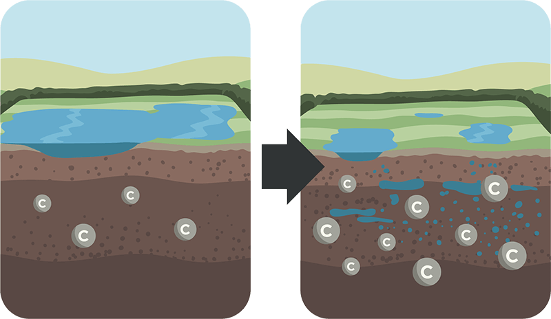
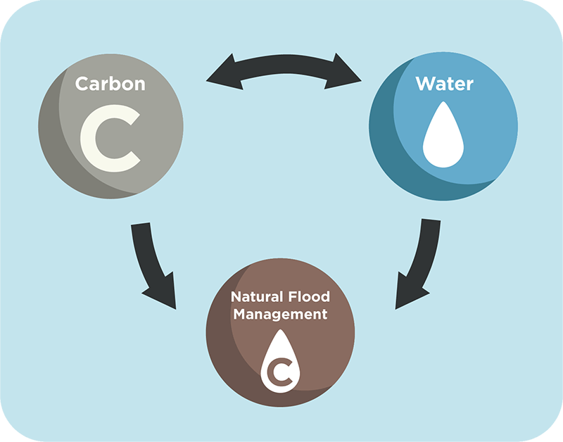
Our work showed that by improving soil carbon, we can enhance water retention and support better flood management. This research helps to show the benefits of soil and land management and provides an indication of the benefits of increasing soil carbon. Increasing water retention in the soil is beneficial for both flood prevention and drought resilience.
We also looked at how the biodiversity influences soil organic carbon and implications for maximising carbon sequestration.
Methods
Soil’s ability to hold water depends on its texture and bulk density. Soil Organic Carbon (SOC) plays a key role in improving soil pore connections, reducing bulk density, and increasing water storage.
Previously, the NFM Studio hydrology model used standard values for these properties across different soil types.
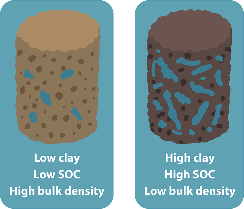
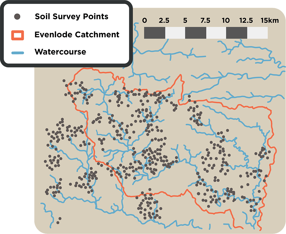
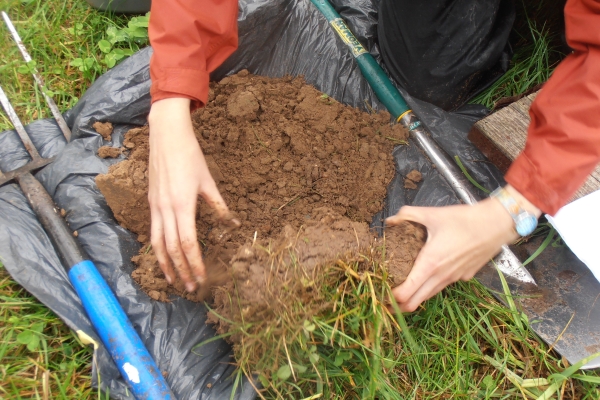
Now, Carbon Quester has measured texture, SOC, and bulk density in over 700 fields, covering arable land, pastures, and floodplain meadows.
This detailed data improves the accuracy of the hydrology model, making it a valuable tool for land use planning and scenario testing. By using local data, we can achieve more precise results, including modeling how SOC changes under different scenarios.
Findings
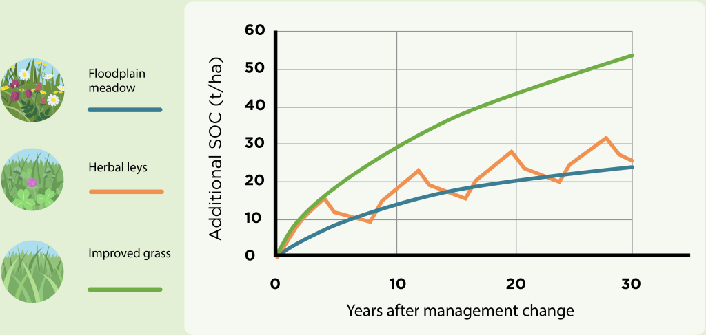
Land use options
Floodplain restoration (from arable)

Nutrient stripping and establishment of floodplain plant communities by spreading green hay. Reduced soil fertility and a more stress tolerant plant community means lower biomass and carbon inputs than improved grassland. But plant residues break down more slowly and fields will regularly flood meaning the rate of loss will be lower than in improved grassland.
Integration of short term leys

Rotation of perennial grass / clover leys with annual crops (in our scenario, we grow leys for 4 years, followed by 4 years of annual cropping). Soil carbon will increase during the ley phase at a similar rate to improved grassland but be lost when the soil is cultivated.
Arable reversion to improved grassland

Establishment of permanent grass swards for grazing or silage with organic or inorganic fertiliser inputs maintaining high soil fertility and biomass production. Perennial, competitive plant communities have high rate of carbon input : lack of soil disturbance and bare ground limits the rate of loss.
We applied three examples of practice change to real-world cases from the North-East Cotswold Farming Cluster. By using our improved hydrology model along with Carbon Quester’s soil carbon data, we were able to show increases in soil carbon sequestration and better water retention in these soils.
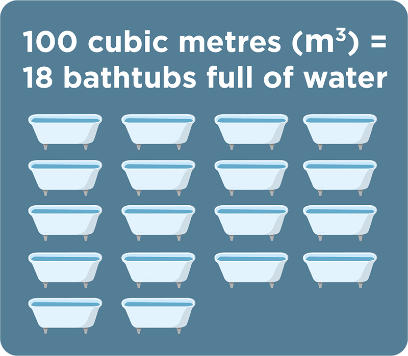

The case studies are modelled over a 30 year period.

Project Outputs
Case Studies
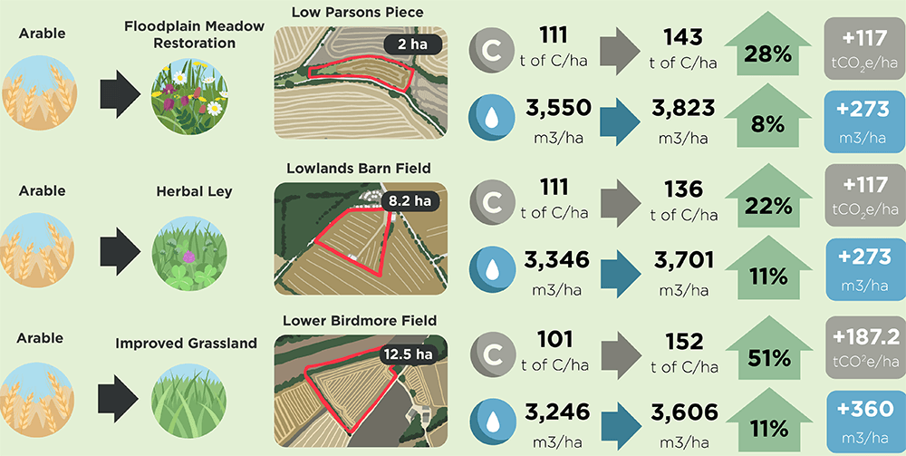
Case Studies 1 – Elmton Soils (fine loamy soils over limestone)
These three examples of practice change are applied to real-world examples from the North-East Cotswold Farming Cluster to show how our improved hydrology model, combined with Carbon Quester’s soil carbon dataset, show modelled uplift in soil carbon sequestration and increased water retention in soils.
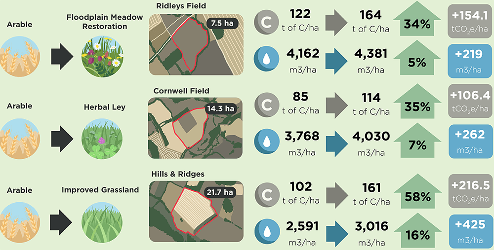
Case Studies 2 – Oxpasture Soils (Clayey soils, slowly permeable subsoils)
These three examples of practice change are applied to real-world examples from the North-East Cotswold Farming Cluster to show how our improved hydrology model, combined with Carbon Quester’s soil carbon dataset, show modelled uplift in soil carbon sequestration and increased water retention in soils.
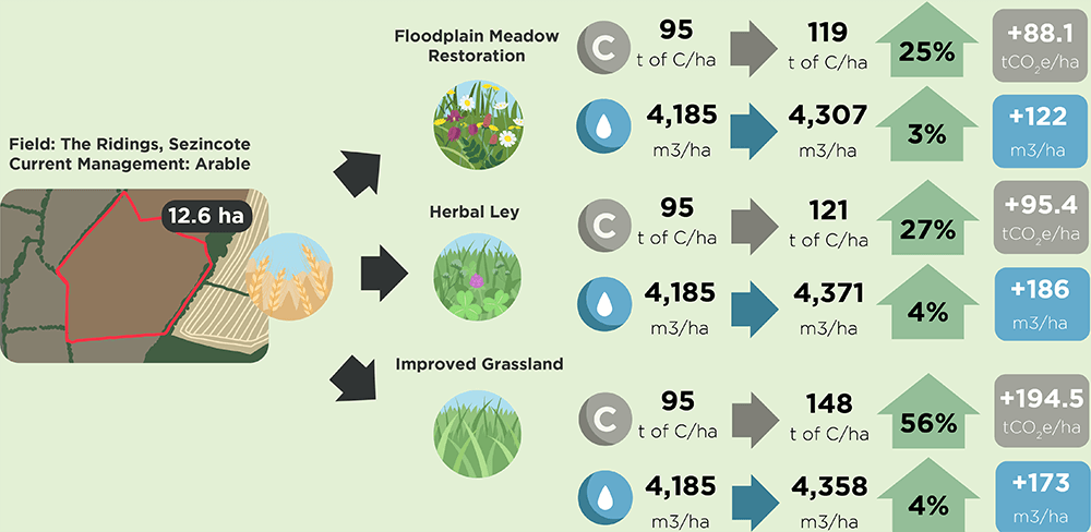
Case Studies 3 – Practice Change for one field (Denchworth soil type – slowly permeable, clayey soils)
These three examples of practice change are applied to one example field from the North-East Cotswold Farming Cluster to show how our improved hydrology model, combined with Carbon Quester’s soil carbon dataset, show modelled uplift in soil carbon sequestration and increased water retention.
Conclusion
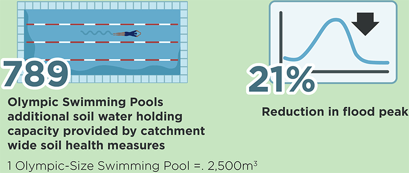
Increasing the soil water storage capacity can help increase catchment water resilience to both flooding and drought.

Videos
Soil Carbon and Water Resilience Day at FarmED
Below are three recordings from an event which took place on October 10th, 2024 at FarmED, Honeydale Farm, near Chipping Norton in the UK. It gave participants a chance to hear about novel soil carbon research and hydrology modelling, with the ambition that it will enable farmers, businesses and government to understand the key implications and potential value of soil carbon and its impact on water retention and resilience. The research was applied to case studies within the North East Cotswold Farmers Cluster’s projects, and the whole of the Evenlode catchment has been modelled for potential natural flood management opportunities.
Chaired and part presented by Tim Field (representing the North East Cotswold Farmers Cluster), speakers included Sally White and Izzy Edwards from the Environment Agency, Chris Sworder from Carbon Quester, Jon Storkey from Rothamsted Research, and Emily Brown from AtkinsRéalis. The day consisted of a series of presentations with opening remarks from the Environment Agency, an update on the landscape-scale recovery initiatives happening in the North East Cotswolds, a recap of the NEIRF project, Atkins’ hydrology modelling work, and the Soil Carbon and Water Resilience Project findings and case studies. This was followed by a panel discussion with Q and As on soil carbon variability and trade offs, before looking at next steps in the Cluster and a tour of the demonstration farm.
Soil Carbon and Water Resilience Day at FarmED – Part 1 (Intro, opening remarks from the Environment Agency, update on the landscape-scale recovery initiatives)
Soil Carbon and Water Resilience Day at FarmED – Part 2 (Information on the NEIRF project, Atkins’ hydrology modelling work)
Soil Carbon and Water Resilience Day at FarmED – Part 3 (Soil carbon variability and trade offs and what’s next in the Cluster)
Project partners:
- The North East Cotswold Farming Cluster: A collective of farmers focused on sustainable farming and landscape-scale regeneration.
- Carbon Quester: Specialist in soil carbon baselining at landscape scale.
- AtkinsRéalis: A global leader in professional services, engineering, and project management, promoting sustainable solutions.
- Rothamsted Research: A world-renowned agricultural research institute dedicated to advancing sustainable farming and food security.
- Environment Agency: The Environment Agency works to create better places for people and wildlife, and supports sustainable development.
